


Introduction
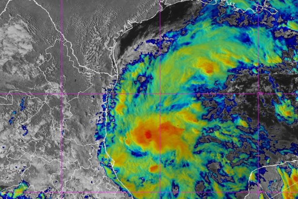
The hurricane tracker picture is changing quickly as Tropical Storm Isaias strengthens over the Gulf of America and heads toward a potential U.S. Gulf Coast encounter. The National Hurricane Center upgraded Tropical Depression Nine to Tropical Storm Isaias early Wednesday after satellite and surface observations showed the circulation becoming better organized. National Hurricane Center
As of the latest NHC forecast, Isaias had maximum sustained winds of 35 knots, or about 40 mph, and was moving east-northeast. Forecasters expect additional strengthening before the system turns toward the northern Gulf Coast. National Hurricane Center
The exact landfall location and final intensity remain uncertain. But the threat is serious enough that residents from Louisiana through the Florida Panhandle are being urged to monitor the forecast closely.
Background and Context
The storm began as a broad area of low pressure in the southwestern Gulf. By Tuesday, the National Hurricane Center had designated it Tropical Depression Nine after the system developed a closed circulation and increasingly organized thunderstorms. National Hurricane Center
That evolution accelerated overnight.
At 4 a.m. CDT Wednesday, the NHC upgraded the system to Tropical Storm Isaias. The agency said a buoy north of the center reported sustained winds of 35 knots, helping confirm that the system had reached tropical-storm strength. National Hurricane Center
The timing matters because the Gulf contains exceptionally warm water, providing fuel for tropical development. FOX Weather reported that Gulf waters were at their warmest levels on record dating back to 1982, although atmospheric conditions will still determine how efficiently Isaias can intensify. FOX Weather
This is also an unusually late-season development.
The 2026 Atlantic season had gone without a hurricane through September, an extraordinary stretch considering that September is normally the climatological peak of Atlantic hurricane activity. Isaias could end that drought.
Latest Update or News Breakdown
Isaias is officially a tropical storm
The most important update is that the system is no longer simply Tropical Depression Nine.
The NHC’s 9 a.m. UTC advisory placed Tropical Storm Isaias near 22.0°N, 94.1°W, with maximum sustained winds of 35 knots and gusts to 45 knots. The storm was moving east-northeast at about 7 knots. National Hurricane Center
The official forecast calls for significant strengthening.
The next forecast period already shows winds reaching 50 knots, and forecasters expect Isaias to continue intensifying as it crosses the Gulf. National Hurricane Center
For the latest mainstream coverage, CNN’s report describes the system as a rapidly strengthening tropical cyclone with the potential to become a hurricane before reaching the U.S. Gulf Coast. CNN’s Gulf Coast hurricane threat report
The potential track points toward the northern Gulf Coast
Forecast guidance has increasingly focused attention on the coastline from Louisiana to the Florida Panhandle.
FOX Weather’s earlier forecast showed the system moving east of the Yucatán Peninsula before turning north toward the northern Gulf Coast, with Louisiana, Mississippi, Alabama and the Florida Panhandle among the areas requiring attention. FOX Weather
The important caveat is that a forecast track this far ahead is not a precise landfall prediction.
Small changes in steering currents can shift the eventual center by dozens or even hundreds of miles. That means residents should pay attention to the official forecast cone rather than focusing on a single projected landfall point.
Rain could become a bigger threat than the wind
Hurricanes often dominate headlines because of their wind speeds, but rainfall may ultimately become one of Isaias’ biggest hazards.
Weather forecasts indicate that heavy rain could spread across portions of the Gulf Coast and Southeast beginning later this week. Some forecasts have suggested several inches of rain, with locally higher totals possible. Weather.com
The National Weather Service has already highlighted the potential for heavy rainfall and high winds along the northern Gulf Coast as the system approaches. National Weather Service
Flooding risk can extend well beyond the immediate coastline.
A storm does not need to make a direct landfall over a particular community to create dangerous rainfall there. Tropical moisture can travel hundreds of miles inland, especially when a storm interacts with larger weather systems.
Gulf Coast states are watching closely
Louisiana, Mississippi, Alabama and the Florida Panhandle are currently among the areas receiving the most attention.
The NWS Mobile forecast discussion said Tropical Depression Nine was expected to approach the northern Gulf Coast Friday, with the potential for heavy rain and high winds. National Weather Service
The NWS Jacksonville office similarly warned that the system was expected to move toward the northern Gulf Coast and intensify, with heavy rain and potential flash flooding among the expected local impacts. Marine Weather
That does not mean every location in those states will experience hurricane conditions. The eventual intensity, size and track will determine which communities face the greatest threat.
Expert Insights or Analysis
Why the Gulf is capable of rapid intensification
Warm ocean water is one of the basic ingredients hurricanes need.
A tropical cyclone can draw heat and moisture from the ocean, converting that energy into stronger thunderstorms and lower central pressure. When upper-level winds are also favorable, a storm can intensify surprisingly quickly.
Isaias is entering a Gulf environment where ocean temperatures are highly supportive of tropical development. FOX Weather noted the exceptional warmth of Gulf waters, while NHC forecasts anticipate strengthening. FOX Weather
But warm water alone does not guarantee a major hurricane.
Wind shear, dry air, storm structure and the amount of time the circulation spends over water all matter. That is why the forecast can change substantially as new reconnaissance and satellite data become available.
Hurricane Hunters are gathering better data
Reconnaissance aircraft are particularly valuable in a developing storm because satellite imagery cannot directly measure every feature inside the circulation.
The NHC had scheduled aircraft reconnaissance for the system while it was still developing as a depression. National Hurricane Center
Those measurements help forecasters establish the storm’s center, pressure, wind field and surrounding atmospheric environment.
For a storm such as Isaias, those details can improve both track and intensity forecasts during the crucial period immediately before landfall.
The forecast is about probabilities, not certainty
One of the biggest mistakes people make when following a hurricane tracker is treating the center line of a forecast map as a guaranteed path.
It is not.
The cone represents uncertainty in the forecast track. Impacts such as rain, storm surge, tornadoes and strong winds can extend well outside the eventual centerline.
That means someone outside the center of the cone should not assume they are automatically safe.
Broader Implications
Isaias could become the first Atlantic hurricane of 2026
If the storm reaches hurricane strength, it would end an unusually long Atlantic hurricane drought.
FOX Weather reported that Isaias was forecast to become the basin’s first hurricane of the season. FOX Weather
That would make this storm notable even before considering its potential U.S. impacts.
But the historical distinction should not distract from the practical issue. Whether Isaias reaches Category 1, Category 2 or remains weaker, heavy rainfall and coastal hazards can still create dangerous conditions.
The storm could affect a large area
The potential impact zone is broader than the eventual landfall point.
Coastal communities could face storm surge, dangerous surf, rip currents and strong winds. Inland communities could see heavy rain, flash flooding and, depending on the storm’s structure, isolated tornadoes. Local News 8
That makes preparation difficult because residents need to consider multiple hazards rather than simply asking, “Where will the hurricane hit?”
Why hurricane tracking technology matters
Modern hurricane forecasting combines satellite imagery, reconnaissance aircraft, ocean observations, computer models and increasingly sophisticated data assimilation.
The result is a much clearer picture of a storm than forecasters had decades ago.
But uncertainty remains unavoidable. The atmosphere is a chaotic system, and a difference in steering flow or storm organization can change the forecast.
For more coverage of technology, data and the systems shaping how people understand major events, visit The Tech Marketer.
Related History or Comparable Technologies
The 2026 Atlantic season has already been unusual because of how long it went without a hurricane.
September traditionally produces a large share of Atlantic hurricane activity. Yet the basin reached October without a hurricane, according to weather reports tracking the season. FOX Weather
That makes Isaias a useful reminder that hurricane season does not end simply because the calendar reaches autumn.
The official Atlantic hurricane season runs from June 1 through November 30. FOX Weather
October can actually be an important month for Gulf and Caribbean systems because weather patterns shift. Cold fronts and troughs can interact with tropical disturbances, while warm water can remain available to support development.
For residents, that means hurricane preparedness remains relevant well after the traditional summer peak.
What Happens Next
The next 24 to 48 hours are critical.
The National Hurricane Center expects Isaias to strengthen while moving across the Gulf. The current forecast takes the system toward the northern Gulf Coast later this week. National Hurricane Center
The exact landfall location is still uncertain, so residents should monitor official forecasts rather than relying on older screenshots, social media maps or model runs.
People in potentially affected areas should consider basic preparations now:
- Monitor the National Hurricane Center and local National Weather Service office.
- Check evacuation routes and local emergency instructions.
- Secure loose outdoor objects.
- Review backup power and communications plans.
- Keep medications, important documents and essential supplies accessible.
- Do not drive through flooded roads.
- Treat official evacuation orders as authoritative.
There is no need to panic based solely on a forecast cone. But waiting until a storm’s final track is obvious can leave households with fewer options.
Conclusion
The hurricane tracker story has changed rapidly in less than 24 hours.
What began as Tropical Depression Nine is now Tropical Storm Isaias, with winds of about 40 mph and a forecast calling for additional strengthening. National Hurricane Center
The system is expected to move toward the northern Gulf Coast later this week, potentially bringing heavy rain, strong winds, coastal flooding and other hazards from Louisiana toward the Florida Panhandle.
The biggest unknown remains the final track and intensity.
For now, the most useful advice is simple: watch the official forecast, prepare early if you are in the potential impact zone, and remember that dangerous weather can extend far beyond the point where the storm’s center eventually comes ashore.
FAQ
1. What is the latest hurricane tracker update for Isaias?
Tropical Storm Isaias is moving east-northeast over the Gulf and is forecast to strengthen as it approaches the northern Gulf Coast later this week. The latest NHC advisory lists maximum sustained winds of 35 knots. National Hurricane Center
2. Is Isaias a hurricane yet?
No. As of the latest NHC advisory used for this article, Isaias is a tropical storm. Forecasters expect it to strengthen and potentially become a hurricane later this week. National Hurricane Center
3. Where is Tropical Storm Isaias headed?
The forecast takes Isaias toward the northern Gulf Coast. Louisiana, Mississippi, Alabama and the Florida Panhandle are among the areas being closely monitored. FOX Weather
4. Could Isaias become a major hurricane?
Current forecasts call for significant strengthening, but the ultimate intensity remains uncertain. FOX Weather reported that the NHC forecast Isaias could reach Category 2 strength, while the exact track and atmospheric conditions will influence how strong it becomes. FOX Weather
5. When could Isaias reach the Gulf Coast?
Current forecasts point to the end of the week, with the northern Gulf Coast potentially seeing the most significant impacts around Friday and into the weekend. National Weather Service
6. What states could be affected by Isaias?
Louisiana, Mississippi, Alabama and Florida are among the states potentially facing impacts. Heavy rain could also spread farther inland across the Southeast. FOX Weather
7. Is there a hurricane warning for Isaias?
The latest information used here does not indicate a hurricane warning. Residents should check the National Hurricane Center for the newest watches and warnings because those can change as the storm approaches land.
8. Where should I track Isaias?
The National Hurricane Center is the primary source for official storm advisories, forecasts, watches and warnings. Commercial hurricane trackers can provide useful visualizations, but official government advisories should guide safety decisions.
Sources & References
- CNN: “Gulf Coast faces hurricane threat as Tropical Depression Nine is forecast to strengthen.” Read the CNN report
- FOX 8: “Tracking tropical system to bring widespread rain.” Read the FOX 8 report
- FOX Weather: “Tropical Depression Nine forms in the Atlantic on track to be first dangerous hurricane of the season.” Read the FOX Weather report
- National Hurricane Center: “Tropical Storm Isaias Forecast/Advisory Number 3.” Read the official NHC advisory
- National Hurricane Center: “Tropical Storm Isaias Discussion Number 3.” Read the official forecast discussion